BLYTHEWOOD – A request for approval of a sketch plan that was previously approved by a former planning commission was recommended for ‘approval with conditions’ Monday evening by the current planning commission. The vote was 2-1 with Commission Chairman Donald Brock, who is the Oakhurst Home Owners Association president, abstaining.
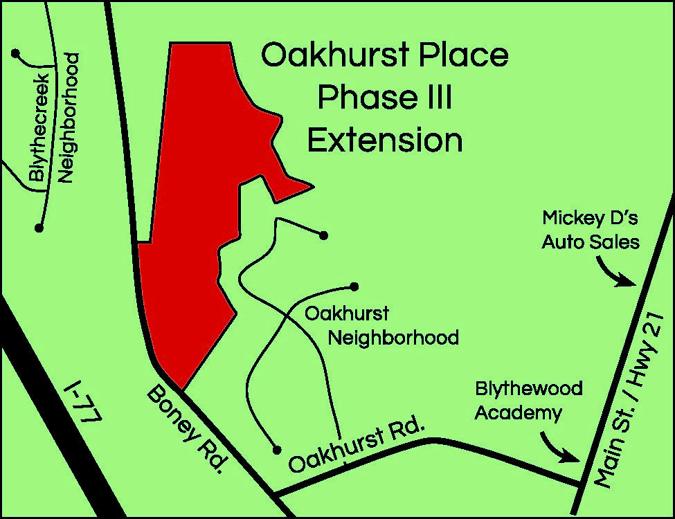
Bucky Drake of Drake Development and property owner Jim Perryman requested sketch plan approval for Oakhurst Place Phase III, a 12-parcel, eight-acre site located in the rear of the existing Oakhurst Subdivision off Oakhurst Road.

Town Administrator Brian Cook explained that the previous approval for the property was given in May of 2017 as Cambridge Point. That proposed subdivision included the lots reviewed Monday night, but also numerous other lots across a stream and going back toward Boney Road.
Because the approved Cambridge Point subdivision was never started, the former approvals have expired.
At issue Monday evening were four flag lots – lots with narrow strips of driveway extending back to the buildable portion of the lot.
In a memo to commissioners, Cook said those driveways would connect two cul-de-sacs in the established Oakhurst subdivision to the four parcels landlocked by wetlands on the backside and otherwise surrounded by current Oakhurst residential properties.
Four Oakhurst residents spoke during open comment time objecting to the flag lots saying they posed numerous problems.
“I don’t have any issues with the proposed eight conforming lots, but I am concerned with four of the lots I consider non-conforming…you usually see these in rural areas, not in planned neighborhoods,” Oakhurst resident Chris Shull, a realtor, said. “I’m also concerned about emergency vehicles being able to get down these long driveways.”
Resident Danielle Andes expressed concern that traffic would be a nuisance since the long driveways would border existing Oakhurst properties and allow homes to be built behind current homes. She cited what she felt were topography issues (steep inclines) that would allow runoff from the steeper flag lots to drain onto her property below. She also suggested wetlands could be an issue in the development of the flag lots.
“We can address emergency access to these driveways by increasing their width and working with the fire department regarding requirements,” Engineer Derrick Boyt said. “And we are staying out of the wetlands area. We’ve had some flooding, but I design it so that it doesn’t flood under normal conditions.”
“This is a topo (topography map) of the land and the topo runs away from any other lots,” Perryman said. “The wetlands have been delineated, so the proposed homes will be away from and in compliance with the wetlands.”
Perryman said he didn’t know why these issues were being raised now. He said that he and Drake had met with Brock, then a commissioner, the (then) Town Planning Consultant Michael Criss and the (then) commission chair about two years ago to redesign a plan and that was ultimately approved by the commission.
But the original plan [proposed in December of 2016] did not include flag lots. Instead, the town’s masterplan called for an internal street connection system between the established Oakhurst subdivision and the proposed new subdivision. That interconnectivity, home density and traffic didn’t sit well with the Oakhurst homeowners who objected to their neighborhood serving as a cut-through for the proposed neighborhood.
The developer came back to the commission on May 1, 2017 with a reduction in the number of lots, larger sized lots and the removal of an internal bridge and the internal street connection system that connected Oakhurst to the proposed subdivision. Lots on the west side of the project would have access to Boney Road, and lots on the east side would be connected to the Oakhurst subdivision.
However, Criss noted that the new plan also included a number of flag lots.
“[Flag lots] are discouraged in your code but not prohibited,” Criss said, “so the question is how many flag lots are too many.”
“The flag lots would make it easier for occupants to get in and out of the lot without facing such steep inclines,” John Thomas, the developer’s engineer at the time, said.
“The shape of the lots and the way it has turned out had to do with the terrain on that side of the creek; it’s extremely steep coming off the back of Oakhurst,” Thomas said. “So that’s why we put the flag lots there, to utilize land where the accesses are at a fairly level place, so that you’re not going down a real steep slope to try to get in and out of the lot.”
Using flag lots will allow developers to keep more of the tree cover in the area, and preserve more of the natural environment along the creek bed, Thomas said.
Brock said at the May, 2017 meeting he was not concerned with the use of flag lots. “I understand Mr. Criss’s concerns about flag lots. It looks to be four of 12 lots where you have that, not a big cause of concern in my opinion,” Brock said.
The Commission unanimously granted approval to the changes.
“Is there anything in this presentation that is not according to code?” Perryman asked Cook just prior to Monday night’s vote.
“Well, yes,” Cook said, citing Code 153.073(j) that says flag lots are to be discouraged as a land development practice.
“Planning commission has the authority under certain circumstances to vary design standards due to the physical shape or topography of a track of land or other unusual conditions,” Cook said. “So the planning commission has some leeway as to how they want to design the property. That is what it is.”
The commission voted for approval of the sketch plan with the condition that the four flag lots (69, 71, 74 and 75) be removed.
“If there are only going to be eight lots, I don’t think we’re going to try to move forward with it,” Drake told The Voice following the meeting. “We’ve already spent $200,000 trying to develop this property. I’m not going to say we’re absolutely not, but I’m not going to spend a lot more money on it. We’ll see.”


