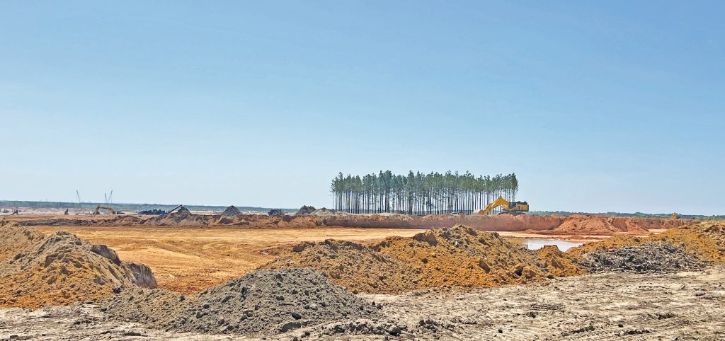
BLYTHEWOOD – As a thousand acres of land was scraped level and cleared of trees over the last six months on the Scout property, a small circle of pine trees – about the only significant vegetation as far as the eye can see on the vast expanse of yellow earth – has been left standing.
Located a short distance west of Fairfield Electric Co-operative, in full view of Blythewood Road, the stand of pines has evoked interest and questions.
Ever since the clearing began, rumors have circulated within the community that a burial ground exists somewhere on the thousand acres. As the clump of pines now stands completely exposed, it is both eerily and artistically stark against the blue sky and its flat earth surroundings, feeding speculation that it could, indeed, be the site of the rumored burial ground.
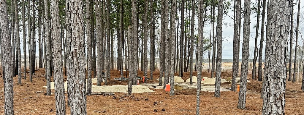
“It is not a burial ground,” Robert Larsen, archaeologist for the S.C. Historic Preservation Office, assured The Voice in February. “The site was determined to be an Indian archaeological site, and is being excavated. But there are no human remains there, only the possibility of artifacts.”
He said it is an archaeological dig where archaeologists are excavating, processing and recording the physical remains of past human cultures.
During The Voice’s visit to the site in mid-February, about three weeks after the dig commenced and a week or so before it was completed, there were two distinct excavations of similar size. Lines of twine pulled taut along the precisely cut edges of the two excavations reflected the work of archaeologists, not construction workers.
Publisher’s Note: The location of the dig was redacted information that Larsen was not allowed to reveal in order to ensure the integrity of the site. The Voice learned of the location of the site from another source not connected to the S.C. State Historical Preservation Office or Richland County. Larsen, however, was allowed to provide other information that appears in this article.
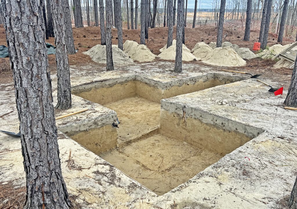
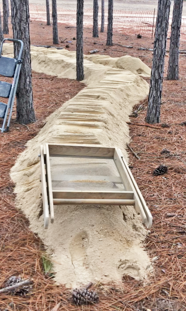
The excavations were shallow, not more than three to four feet deep, and had been dug by hand with long-handled shovels. Three shovels were left at various locations at the site along with sifters and piles of cream-colored sifted sand.
“How deep in the soil the artifacts are, depends on the specific topographical conditions of the area,” Larsen said.
He said the entire tract was surveyed during a cultural resources survey which included locating and identifying the site. It was then determined to be eligible for excavation and data recovery – all of which will be included in a final report that will eventually be made public.
“On the Scout property, we did find one archaeological site which we determined was eligible for the National Register of Historic Places.” Larsen said.
Because the site was situated in a wetlands, Scout Motors required federal permitting concerning jurisdictional wetlands, specifically through the U.S. Army Corps of Engineers. Larsen said this triggered Section 106 of the National Historic Preservation Act.
“Once the site was determined eligible for listing in the National Register of Historic Places,” he said, “a memorandum of agreement (MOA) was executed between our office, the U.S. Army Corps of Engineers and the applicant concerning archaeological data recovery to mitigate adverse effects to the site from the proposed undertaking. Our office, including myself, Elizabeth Johnson and John Sylvest, contributed to developing this MOA. The South Carolina Department of Transportation assisted in facilitating the development of the MOA as well.”
Larsen explained that data recovery is an adequate mitigation effort for an archaeological site so long as it is excavated by professional archeologists – not engineers or construction workers – and properly recorded.
As a requirement of Section 106 and the development of the MOA, the Army Corps of Engineers, as the lead federal agency, was required to consult with the Tribal Historic Preservation Offices concerning the undertaking, the adverse effect determination, the treatment plan concerning the data recovery, etc.
In this case, the Indian tribes deemed necessary to consult were the Catawbas and both bands of the Cherokee (Eastern and Western), the main tribes of interest in South Carolina.
“The tribes determine what they consider to be archaeologically significant,” Larsen said.
“Once we determined that there was integrity in the site, and that it was eligible to be excavated. we requested that the site be ‘data recovered’ …basically, meaning that the archaeologists would screen the entire site and recover all the material and report all the features,” Larsen explained.
The excavations in the field were carried out by S&ME, a Cultural Resources Management firm, based out of their Columbia office. A crew of two field techs and a field director was on site to carry out the data recovery.
“I personally was in the field to oversee the quality of S&ME’s data recovery excavations, that is how our office ensured they met the South Carolina Standards and Guidelines for Archaeological Investigations,” Larsen said.
As part of the MOA, a Treatment Plan was developed concerning the methodologies for the data recovery excavations. Larsen and other personnel contributed to its development with S&ME.
Larsen said there are several known pre-historic or pre-contact archaeological sites in Blythewood, extending back to the Paleoindian Period.
“That is the earliest period of Native American occupation in North America,” he said. “Those sites are roughly 12,500 BC to 13,000 BC.”
However, Larsen said the significant portion of the Scout site which warranted excavations were from the Middle Archaic period.
“Data recovery, while intended to recover as much data and subsurface feature as possible,” Larsen said, “it is often not feasible to excavate an entire site due to often diminishing returns. These excavations were targeted at where the high densities of artifacts and subsurface features were known.
“S&ME is currently conducting lab work to analyze the artifacts assemblage recovered, including gathering C-14 dates – a method of age determination that depends on the decay to nitrogen of radiocarbon (carbon-14),” Larsen said.
Once the lab work is complete, Larsen’s office will work to prepare public information components.
“This will likely include a paper/presentation from our office concerning the archaeological site, its artifact assemblage/subsurface features and positioning the site in larger holistic research on what is currently known of the Middle Woodland period in the Midlands,” he said.
Larsen surmised that it could take up to a year for the review and report on the excavations to be finalized and made public. At that point, he said, any artifacts that might be recovered would be placed either in the Blythewood Historical Museum or the State Museum for public viewing.
“We would consult with them in making that determination,” Larsen said.
There is no word yet, however, on when (or if) the circle of trees will be removed from the site.